WingmateEFB Simulator

New in version 1.1

  • Synthetic vision + PFD
  • PC simulator link
  • Mexico terrain

Your pocket copilot for learning to fly.

Wingmate EFB Simulator · by FM AI

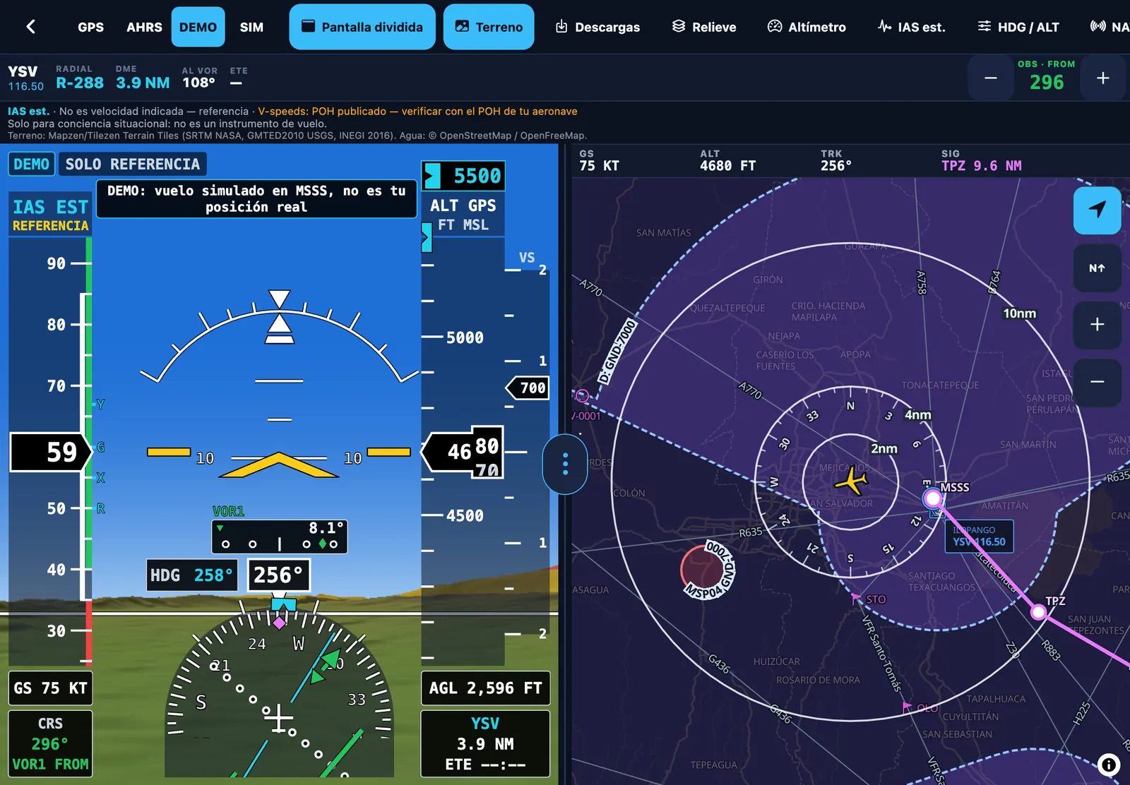
Split screen on iPad: PFD with terrain on the left, moving map on the right

Learn to use an EFB: plan the route, practice with an aviation map and a glass-cockpit PFD with 3D terrain, relive your flights in the logbook and train at home with your PC simulator. Built for El Salvador, Central America and Mexico, at a student price.

A fully functional EFB simulator: a learning and practice tool for student pilots. Not a certified flight instrument.

✓ 7-day free trial on every plan

In the stores as Wingmate EFB

Coming soon to

  • App Store
  • Google Play
  • FAA symbology
  • AIP El Salvador · COCESNA
  • METAR/TAF · aviationweather.gov
  • Works offline

Learning tool

What is Wingmate EFB Simulator?

Wingmate EFB Simulator is a fully functional EFB simulator, designed as a learning and practice tool for student pilots. It is not a certified flight instrument and must not be used as a primary navigation reference.

It is

  • An EFB simulator with the real tools of an electronic flight bag: moving map, charts, NAVLOG, weight and balance, PFD and logbook.
  • A tool to learn, study and practice: on the ground, at flight school and with your PC simulator.
  • A situational-awareness aid, always as a secondary reference.

It is not

  • A certified flight instrument or a primary navigation reference.
  • An EFB approved by AAC El Salvador, AFAC Mexico or any other authority.
  • A substitute for charts, the AIP, NOTAMs, the POH or the aircraft’s instruments.

The whole flight, from the planning table to the simulator

Features are grouped the way you use them at flight school. Each one shows the lowest plan that includes it; every plan includes everything in the one below.

  1. 01 Plan Route, NAVLOG, weight and balance, weather and offline pack
  2. 02 Fly FAA map, AIP charts, VOR, traffic and synthetic vision
  3. 03 After the flight GPS recording, logbook, replay and export
  4. 04 Practice PC simulator, Ground School, plotter, E6B and checklists
  5. PFD Glass cockpit Pro plan · synthetic vision

Lowest plan: Plan Básico+Plan Advance+Plan Pro Real screenshots from app version 1.1 (the app UI is in Spanish).

Plan

On the ground, with time: route, weather, nav log, weight and balance, and everything downloaded to fly without signal.

Plan Advance+

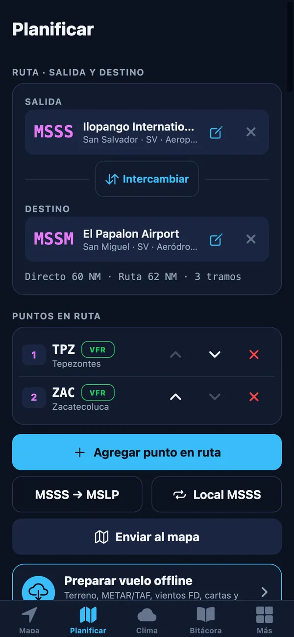
A route builder that goes straight to the map

Pick departure and destination, then add fixes, VFR points, navaids or your own waypoints: Wingmate suggests the ones near your route. Send it to the map in one tap and edit it right there.

  • Point suggestions along the route
  • Send to map, edit on the map and “Direct to”
  • Saved plans for out-and-back trips
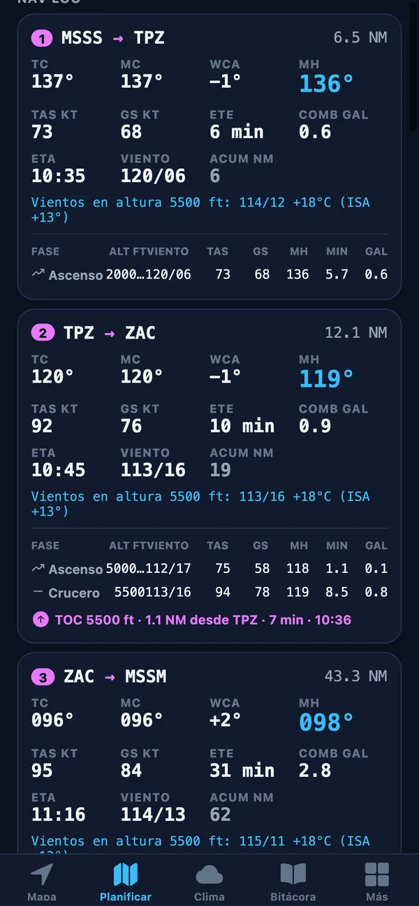
Route builder: departure MSSS, destination MSSM and VFR points TPZ and ZAC
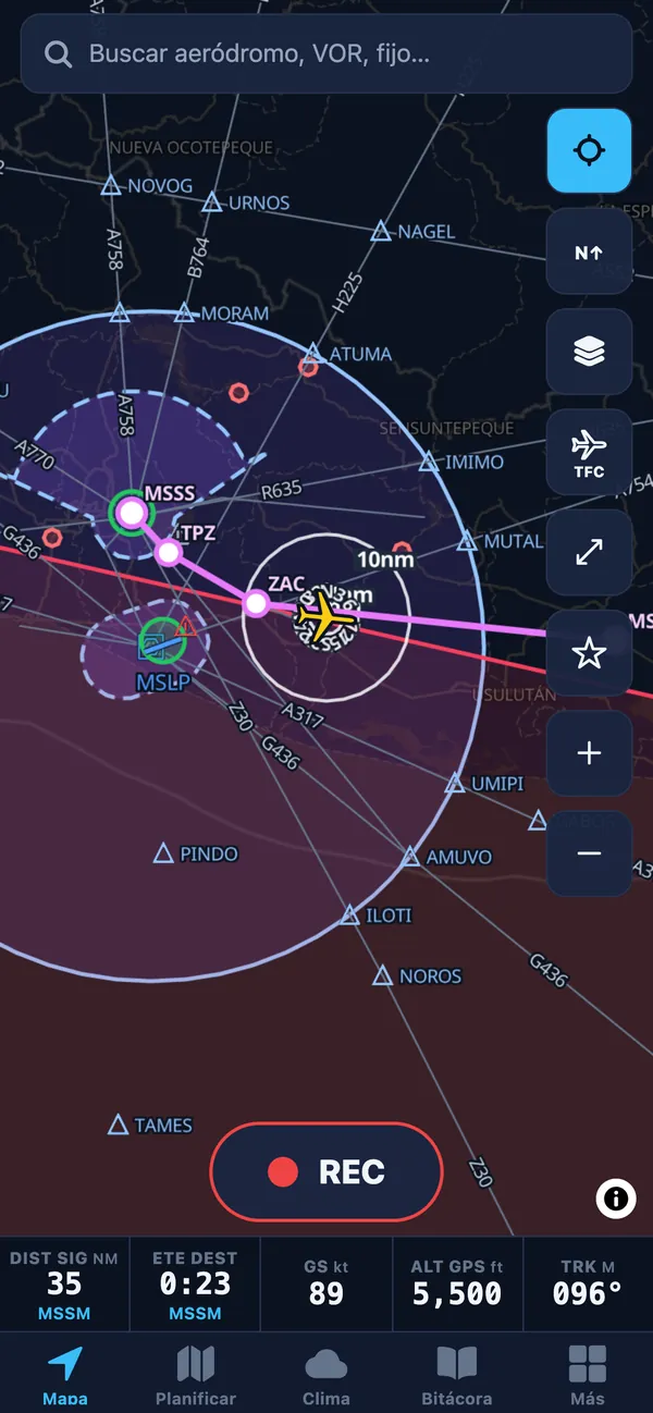
Map on iPhone with the route, ownship, range rings and the data bar

Plan Advance+

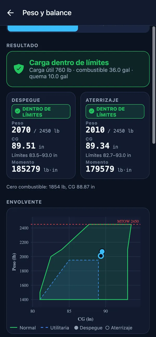
Weight and balance with envelope

Load seats, baggage and fuel, pull the planned burn from your flight plan and check takeoff and landing against your aircraft’s CG envelope.

  • Normal and utility categories
  • Zero-fuel CG and moment
  • School aircraft preloaded
Weight and balance: within limits for takeoff and landing, with the CG envelope

Plan Básico+

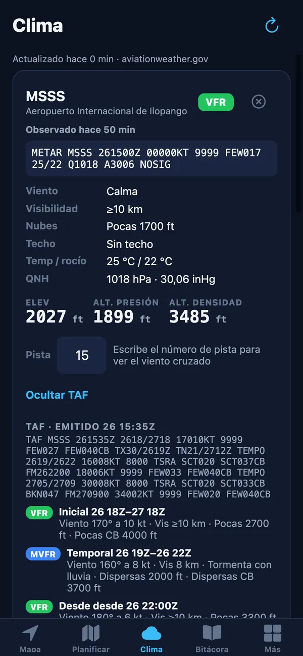
METAR, TAF, SIGMET and NOTAM

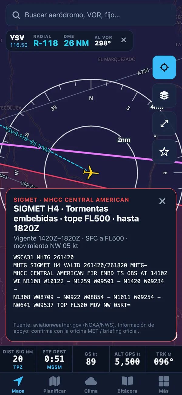
Decoded METAR and TAF with flight category, density altitude and crosswind per runway. On the map: SIGMET, AIRMET, PIREP and NOTAMs for the CENAMER FIR.

  • TAF by period with its category
  • Pressure and density altitude
  • Source: aviationweather.gov (NOAA/NWS)
Weather tab: decoded MSSS METAR and TAF, density altitude and TAF periods with category
Thunderstorm SIGMET on the map, with its text and validity

Plan Advance+

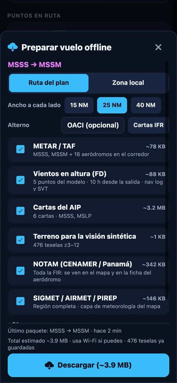
Offline flight pack

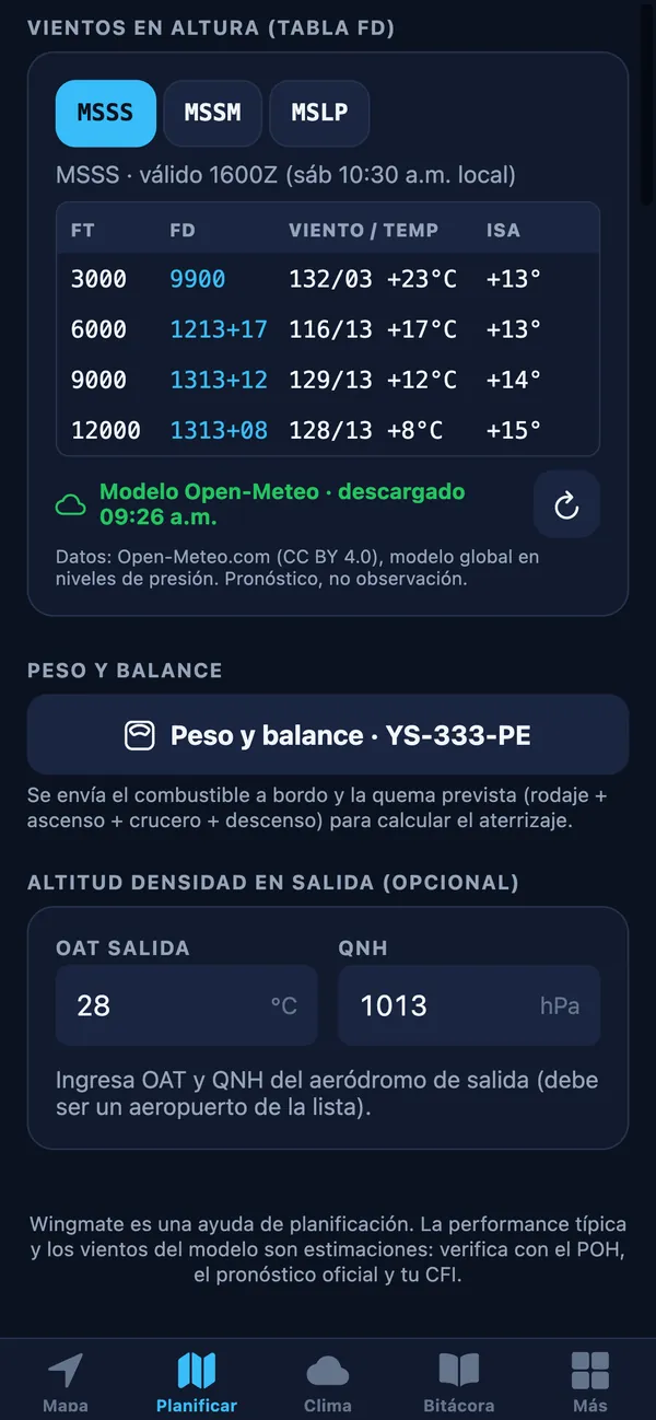
Before takeoff, one tap downloads everything along your route corridor: METAR/TAF, winds aloft, AIP charts, synthetic-vision terrain, NOTAMs and SIGMETs. There is no signal up there; Wingmate does not need it.

  • 15, 25 or 40 NM corridor, or a local area
  • Optional alternate and IFR charts
  • Shows how old each item is
Offline flight pack: METAR/TAF, winds, charts, terrain, NOTAMs and SIGMETs for the route corridor

Fly

In the simulator or as a situational-awareness aid: your position on the aviation map, AIP charts and the glass cockpit. Never as a primary navigation reference.

Plan Básico+

Moving map with FAA symbology

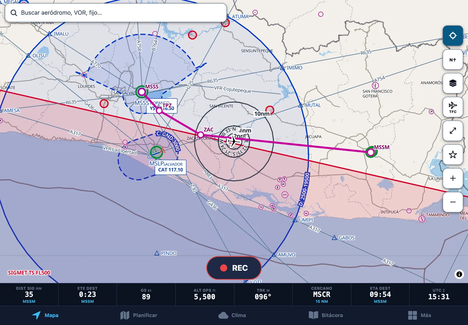
Your live GPS position on an aviation map: airports, VORs, NDBs and fixes drawn with FAA chart symbols, airways, airspace with its limits and your route in magenta.

  • Numbered runways at Central American airports
  • Flight-category rings (METAR) on every airport
  • Aeronautical, IFR Low and Satellite layers; dark, light (sunlight) or automatic theme
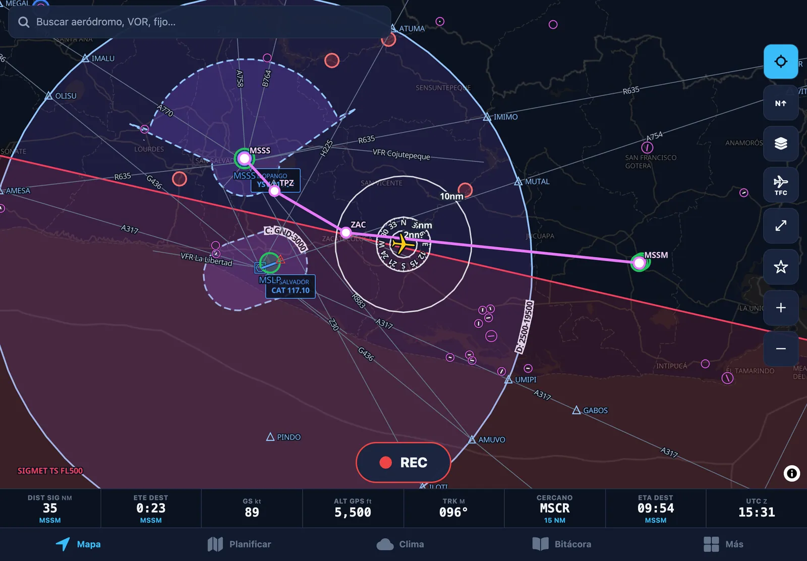
Map on iPad: MSSS–TPZ–ZAC–MSSM route in magenta, airways, fixes, airspace, a SIGMET and flight-category rings
Map on iPhone with the route, ownship, range rings and the data bar

Plan Básico+

Readable in full sun

The light theme is designed for a cockpit in direct sunlight; automatic mode switches with sunrise and sunset.

  • Same data and symbols in both themes
  • Data bar: distance, ETE, GS, altitude, track and ETA
The same map in the light theme for direct sunlight

Plan Básico+

Airport card and AIP charts on the map

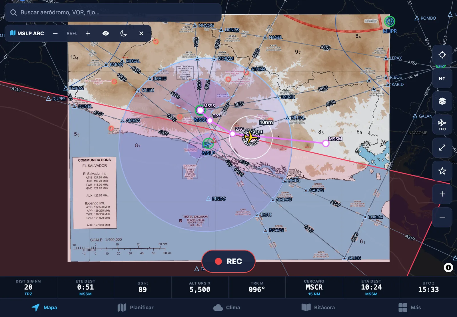
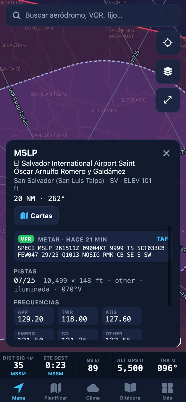
Tap an airport to see its METAR/TAF, runways and frequencies. El Salvador AIP charts for MSLP and MSSS are overlaid georeferenced on the map, with your aircraft on top.

  • Aerodrome, area, SID, STAR and approach charts
  • Chart opacity and night mode
  • AIRAC edition shown; your own PDFs too
MSLP AIP area chart georeferenced on the map, with the route and aircraft on top
MSLP airport card with VFR category, METAR, runway 07/25 and frequencies

Plan Básico+ADS-B traffic: Advance plan

VOR, traffic and your own waypoints

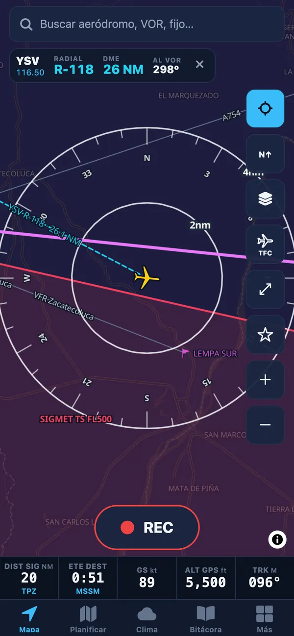
Tune a nearby VOR and see radial, DME and bearing to the station, computed from GPS. Shows ADS-B traffic over the internet where there is coverage, and keeps your own points or imports them as GPX.

  • Center TO/FROM in one tap
  • ADS-B traffic with range and vertical band filters
  • My waypoints: GPX import and export
YSV VOR tuned on the map: radial, DME and bearing to the VOR

Plan Pro

Synthetic vision on your phone too

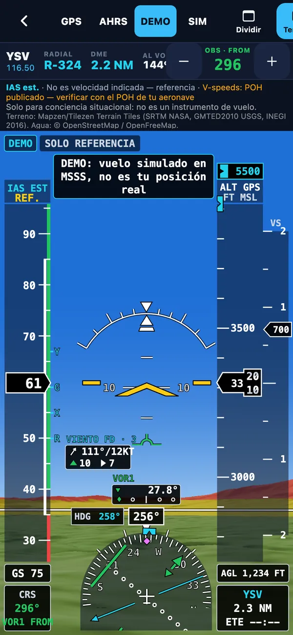
The full PFD with 3D terrain adapts to iPhone and Android phones. See every instrument in detail in the glass-cockpit section.

  • GPS, AHRS or DEMO source
  • HSI on GPS or VOR1
  • Screen stays on in flight
PFD with terrain on iPhone: VOR1, FD wind box, HSI and altitude bug

Pro plan · synthetic vision

A glass cockpit on your iPad or phone

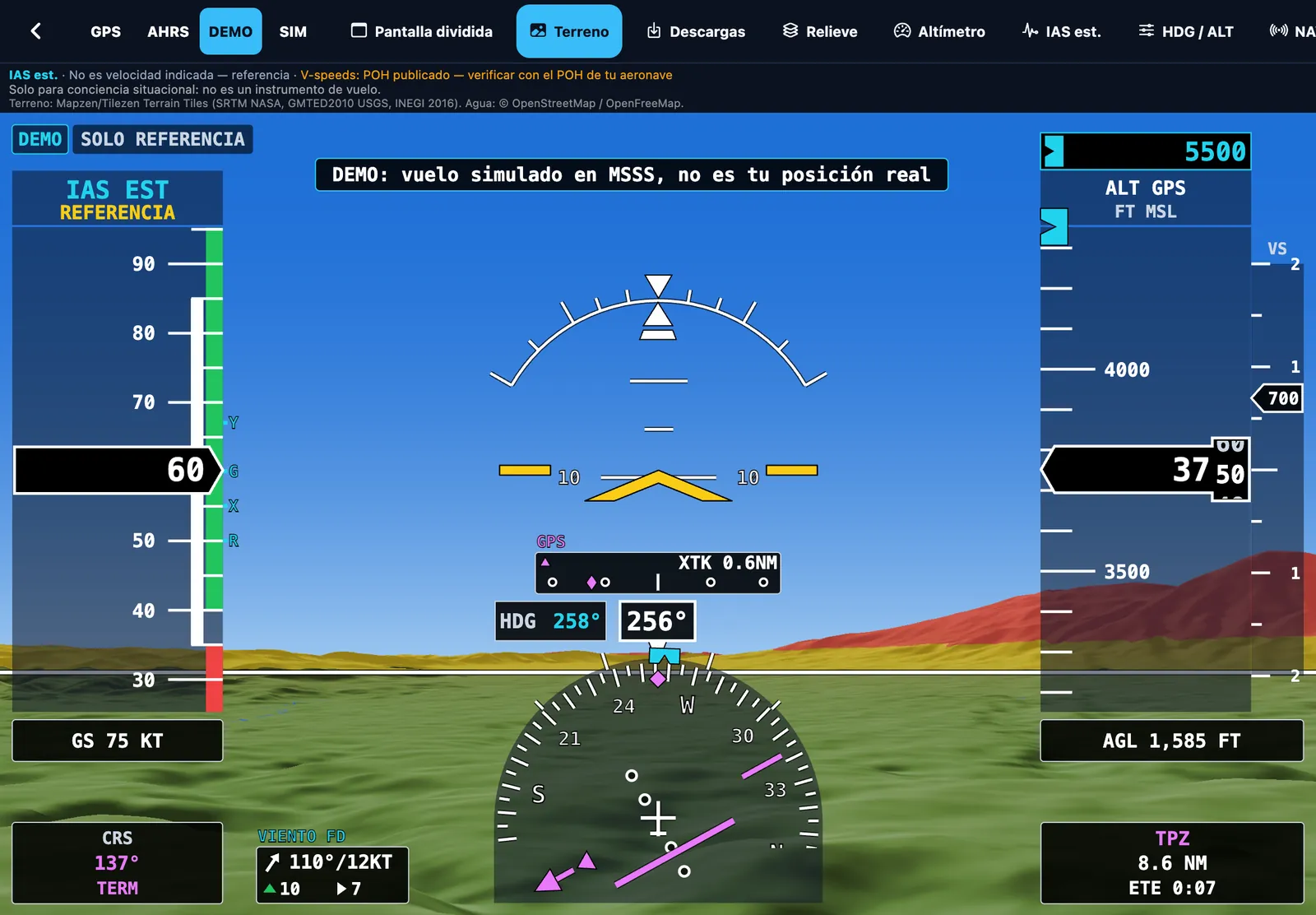
Real 3D terrain with a full PFD, to learn to read a glass cockpit and train your instrument scan. It runs on the device GPS, on its motion sensors (AHRS) or in DEMO mode to practice on the ground.

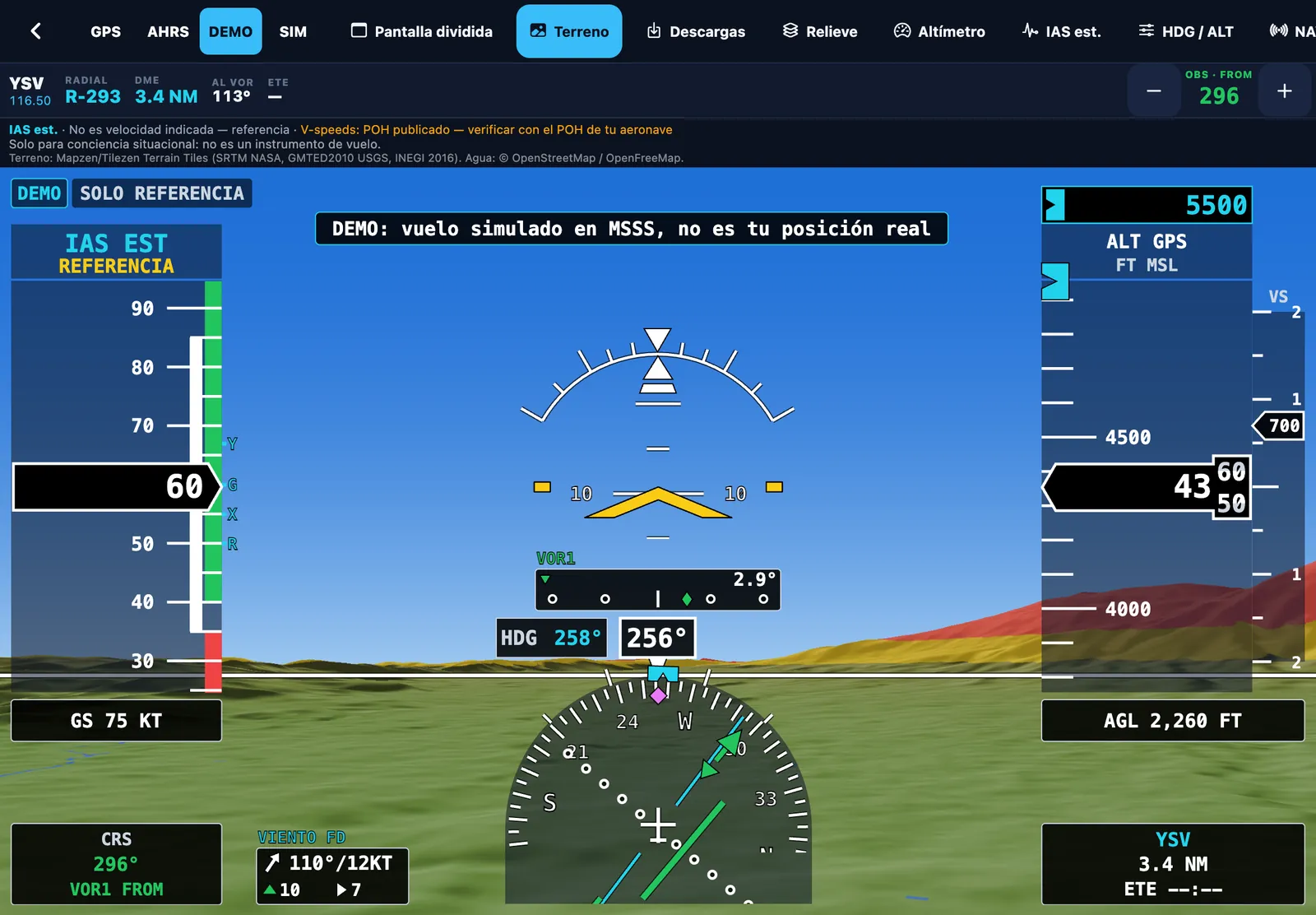
Glass-cockpit PFD with 3D terrain over El Salvador: speed and altitude tapes, HSI on VOR1, HDG and ALT bugs and wind box
  1. ATTITUDE Horizon with pitch ladder

    Pitch ladder, roll scale and a flight path marker (FPM) that shows where the aircraft is actually going.

  2. AIRSPEED Tape with colour bands

    White, green, yellow and red arcs and your aircraft’s V-speed markers (R, X, Y, G). Shows IAS estimated from the wind, or GS.

  3. ALTITUDE Tape with drum and baro setting

    10 ft drum, GPS or barometric altitude, QNH setting in hPa or inHg (from the nearest METAR), AGL and a vertical speed indicator (VSI).

  4. HSI Course, CDI and TO/FROM

    Course pointer and CDI from the GPS route in magenta or from VOR1 in green, TO/FROM flag, bearing needle and turn-rate trend.

  5. CDI Deviation strip

    A CDI strip above the HSI with deviation in dots and cross-track (XTK) or angular error from the course.

  6. HDG / ALT Selectors with cyan bugs

    Cyan heading and altitude bugs, with altitude alerting as you approach or leave the selected altitude.

  7. WIND FD wind box

    Forecast winds-aloft direction and speed, with headwind/tailwind and crosswind components.

  8. SOURCE GPS · AHRS · DEMO

    Uses the GPS, the device gyros (AHRS) or a DEMO flight over MSSS. With the simulator link, a SIM source too.

Three ways to use it

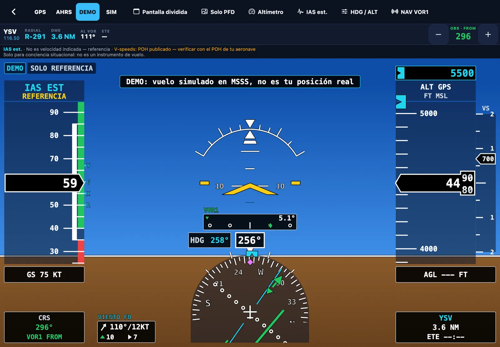
PFD only, no terrain: VOR1 tuned, OBS course, HDG 258° and ALT 5500 bugs and FD wind

3D terrainReal relief with terrain-proximity colours and water.

PFD onlyClassic sky and ground, no terrain: lighter and crisper.

Split screenPFD and moving map side by side, ideal on iPad.

Terrain downloads

  • All of El Salvador
  • Route corridor
  • Around your position
  • All of Mexico · basic
  • Mexico by region (7)

An EFB simulator for learning and situational awareness: not a certified flight instrument or a primary navigation reference.

After the flight

Learn from every flight: your track, your times and your landings, in your logbook.

Plan Pro

GPS recording and logbook with replay

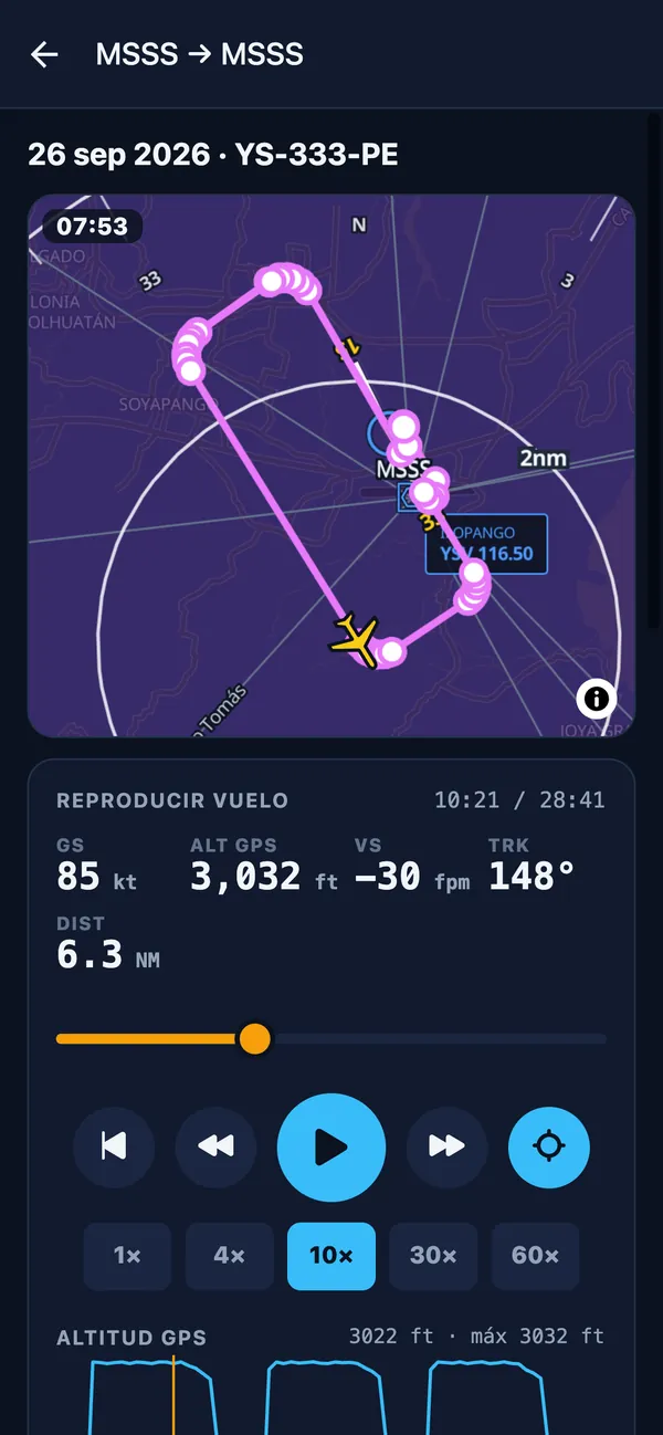
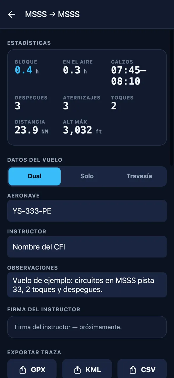
Tap REC and Wingmate logs your GPS track and detects block times, takeoffs, landings and touch-and-gos. Relive the flight with replay and its altitude profile, and export the track in open formats.

  • Block and air time, distance and max altitude
  • Replay from 1× to 60×
  • Export GPX, KML or CSV; manual flights too
Logbook: replay of a pattern-work flight at MSSS with speed, altitude and track
Flight stats (block, air time, takeoffs, landings, touch-and-gos) and GPX, KML and CSV export

Practice

At home or at school: PC simulator, ground school and the navigation tools you already know.

Plan Pro

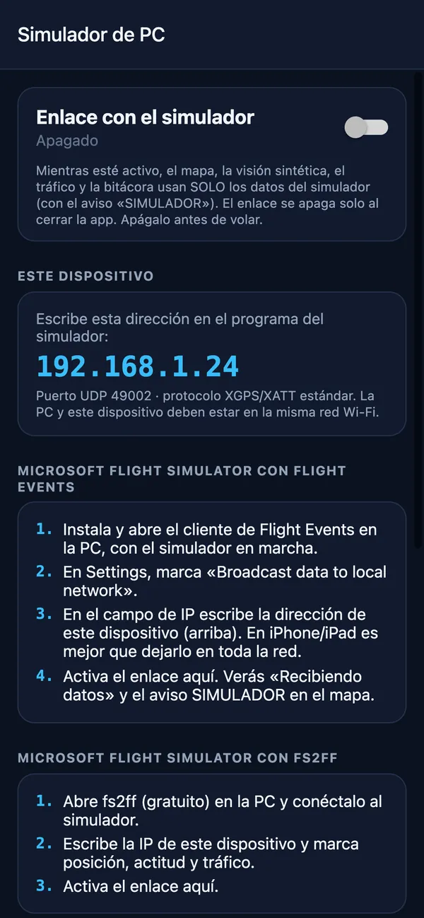
Link to your PC flight simulator

Fly the simulator and use Wingmate just like in the aircraft: the map, the PFD and the logbook receive position, attitude and traffic from the simulator over Wi-Fi.

  • PC and phone or iPad on the same Wi-Fi network
  • In the simulator, turn on data output for navigation apps and enter the IP Wingmate shows (UDP port 49002)
  • Standard XGPS / XATT / XTRAFFIC format: position, attitude and traffic
  • SIMULATOR banner on screen; sim flights are logged separately and do not count as flight time

Works with

  • X-Plane 11 / 12
  • Microsoft Flight Simulator
  • Flight Events

X-Plane is a trademark of Laminar Research; Microsoft Flight Simulator is a trademark of Microsoft; Flight Events is a community project. Wingmate is not affiliated with or endorsed by them.

PC simulator screen: device IP, UDP port 49002 and setup steps

Plan Básico+

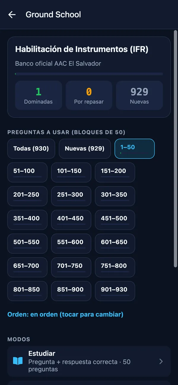
Ground School with the official AAC bank

Prepare for the written exam with the official AAC El Salvador question bank: study, practice, review misses and take a mock exam.

  • 930 instrument-rating (IFR) questions
  • 50-question mock exam, pass at 70%
  • Private and Commercial Pilot: coming soon
Ground School: official 930-question IFR bank from AAC El Salvador, in blocks
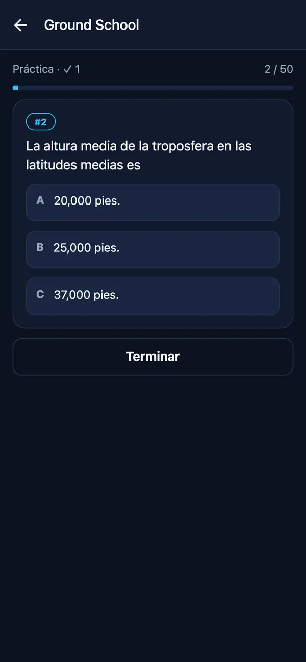
Practice question from the instrument-rating bank

Plan Básico+

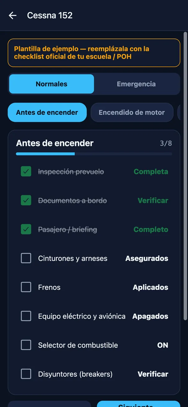
Plotter, E6B calculator and checklists

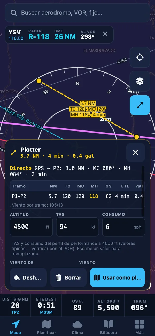
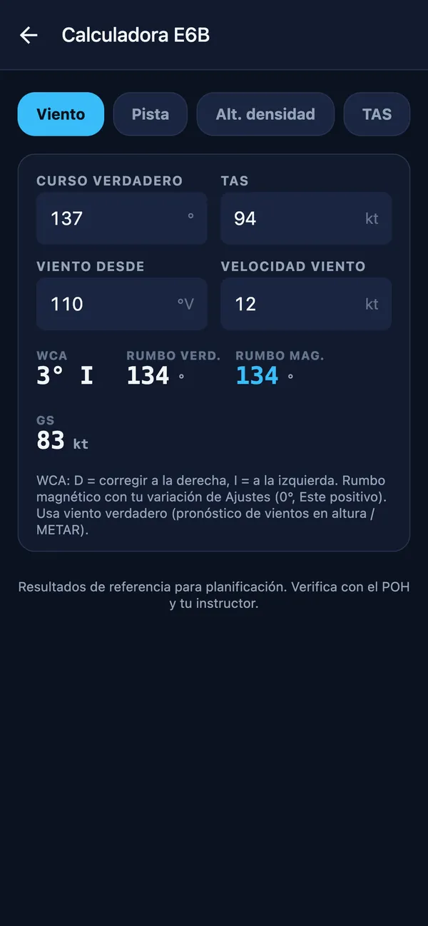
Measure courses and distances on the map with the plotter; solve wind, density altitude, TAS, time-speed-distance and fuel with the E6B; and run normal and emergency checklists you can edit.

  • Plotter with TC, MC, MH, GS and time per leg
  • E6B: wind, runway, density altitude, TAS, T-S-D, fuel and conversions
  • C152, PA-38 and PA-28 templates to adapt to your school
Plotter on the map: a measured leg with distance, TC, MC, MH and time
E6B calculator: wind correction with WCA, heading and GS
Editable Cessna 152 checklist with items checked off

Built to fly without signal

The map engine and aeronautical data ship inside the app, so the map, its symbols and your GPS position keep working with no coverage. Before you leave, the offline pack stores the weather, charts and terrain for your route.

  • Aviation map included in the app
  • GPS needs no mobile data
  • Terrain and charts stored on the device

Pricing

Simple pricing, at a student price

Every plan includes a 7-day free trial. Each plan includes everything in the one below.

Básico

$3.99USD/mo

$39.99USD/yr

$47.88/yr

about $3.33/mo

Map, VOR, charts, weather, plotter, E6B, checklists and Ground School.

Includes:

  • Aviation map with live GPS position
  • VOR tuning
  • AIP charts and your own documents
  • Weather: METAR/TAF, flight category, SIGMET and NOTAM
  • Plotter, E6B, checklists and your own waypoints (GPX)
  • Ground School: AAC question banks
Notify me at launch

✓ 7 days free

Pro

$10.99USD/mo

$109.99USD/yr

$131.88/yr

about $9.17/mo

Everything + synthetic vision/PFD, terrain, logbook and simulator link.
Everything in Advance, plus:

  • Synthetic vision and PFD: AHRS, HSI/CDI, HDG/ALT selectors
  • Terrain downloads and PFD + map split screen
  • Flight recording and logbook with tracks and replay
  • PC simulator link
Notify me at launch

✓ 7 days free

7-day free trial on every plan. Payment method required; renews automatically; cancel anytime from your Apple/Google account.

Prices in US dollars (USD). The App Store and Google Play may show prices in your local currency and include taxes.

Frequently asked questions

What is Wingmate EFB Simulator?

A fully functional EFB simulator, designed as a learning and practice tool for student pilots. It lets you learn to use an electronic flight bag (moving map, charts, NAVLOG, weight and balance, PFD and logbook) on the ground, at school and with your PC simulator.

Can I use it on a real flight?

Wingmate EFB Simulator is a simulator and a learning tool, not a certified flight instrument or a primary navigation reference. If you choose to take it on board, you do so at your own risk and only as a situational-awareness aid: navigate with the aircraft’s instruments and current charts and AIP. The pilot in command decides whether to use a portable electronic device on board and is solely responsible for the operation.

Is Wingmate EFB Simulator a certified flight instrument?

No. It is an EFB simulator for study, training and practice. It does not replace the aircraft’s primary instruments or current charts and AIP, and it is not an EFB approved by AAC El Salvador, AFAC Mexico or any other authority. The pilot in command is solely responsible for the operation. Read the aviation-use notice (Spanish).

When is it available?

Coming soon to the App Store and Google Play as “Wingmate EFB”.

Where does the data come from?

Aeronautical data from the El Salvador AIP (AAC/CEPA) and the Central America AIP (COCESNA); airports from OurAirports; Central American runway numbers from community data; METAR, TAF and SIGMET from aviationweather.gov (NOAA/NWS); winds aloft from Open-Meteo; terrain from SRTM/GMTED models. It may not reflect the current AIRAC cycle or NOTAMs, so always check official sources.

Does it work offline?

Yes. The map engine and aeronautical data ship inside the app, and GPS works without cell signal. With the offline flight pack (Advance or Pro) you download METAR/TAF, winds, charts, terrain and NOTAMs for your route before takeoff. ADS-B traffic does need internet.

How do I connect my simulator?

On the Pro plan, open Más → Simulador de PC. Put the PC and the phone or iPad on the same Wi-Fi network, turn on data output for navigation apps in the simulator (or its link program) and enter the IP Wingmate shows, UDP port 49002. The app includes steps for X-Plane 11/12 and for Microsoft Flight Simulator with Flight Events. It is not a certified simulator (FSTD/BATD) and simulated flights do not count as flight time.

Which devices are supported?

iPhone, iPad and Android phones and tablets. On iPad and tablets you get split screen between the map and synthetic vision.

How does the free trial work?

Every plan includes 7 days free. A payment method on your Apple or Google account is required; if you do not cancel before the trial ends, the subscription renews automatically on the plan you chose.

How do I cancel?

Anytime, from your account: on iPhone/iPad go to Settings → your name → Subscriptions; on Android go to Google Play → Payments & subscriptions → Subscriptions. You keep access until the end of the paid period.

What is the difference between Básico, Advance and Pro?

Básico has the map with aviation data and live GPS, VOR, charts, weather, plotter, E6B, checklists, your own waypoints and Ground School. Advance adds flight planning, NAVLOG PDF, weight and balance, saved plans, route editing on the map, the offline pack and ADS-B traffic. Pro includes everything, plus synthetic vision/PFD with AHRS, HSI and selectors, terrain downloads, split screen, flight recording with logbook and the PC simulator link.